
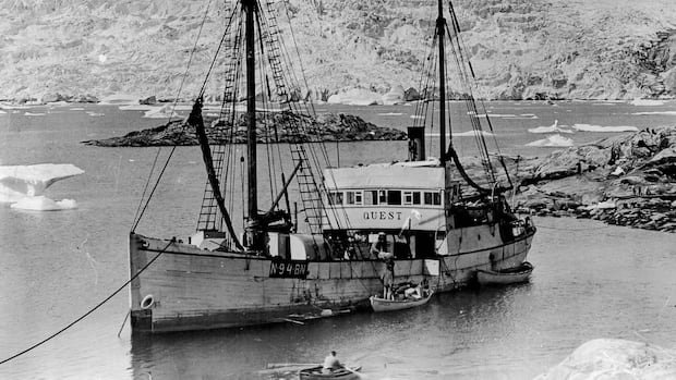

An upcoming expedition funded by the Royal Canadian Geographical Society (RCGS) is set to digitally document the wreck of the Quest, a ship that sank in the Labrador Sea in 1962. The project, starting this week, aims to create a detailed three-dimensional model of the vessel using cutting-edge Canadian underwater imaging technology developed by Voyis, a company based in Waterloo, Ontario. The research team will also survey the Terra Nova, another historic ship associated with British explorer Robert Falcon Scott’s Antarctic expedition.
CBC News will be onboard the research vessel Atlantis for exclusive coverage as scientists explore the shipwrecks. This 21-day expedition departing from the Woods Hole Oceanographic Institute in Massachusetts on July 2 marks a significant shift in underwater archaeology towards digital documentation rather than physical recovery of shipwrecks.
Renowned shipwreck hunter and expedition co-chief scientist, David Mearns, views this venture as a rare opportunity to create detailed digital records of both the Quest and Terra Nova, emphasizing the historical significance of these expeditions. Shackleton’s tragic demise aboard the Quest in 1922 near South Georgia adds to the allure of this exploration.
The Quest, which lies nearly 400 meters below the Labrador Sea, will be meticulously documented to uncover what has endured, changed, and what the wreckage and its surrounding debris field can reveal. The identity confirmation of the ship and exploration of the debris field are pivotal aspects that the team is eager to investigate.
Utilizing advanced imaging technology such as lasers, stereo cameras, and sophisticated software, the expedition plans to create a comprehensive digital twin of the wreck in real-time. This approach ensures precise data collection without the need for divers, offering enhanced safety and accuracy in documenting the shipwrecks.
Voyis, a company specializing in underwater imagery, has been enlisted for this project, leveraging its expertise in creating digital models of renowned shipwrecks like the Titanic and Endurance. The application of digital photogrammetry in underwater exploration facilitates detailed analysis and measurement, enabling researchers to revisit and study the findings long after the expedition concludes.
Despite the excitement surrounding the expedition, challenges loom ahead. The unpredictable conditions of the Labrador Sea, including strong currents and poor visibility, pose potential obstacles for the success of the mission. Navigating the remote-operated vehicle in such conditions requires precision and expertise to capture the necessary data accurately.
The expedition represents a significant milestone in underwater archaeology, showcasing the fusion of cutting-edge technology with historical exploration. The meticulous documentation of these iconic shipwrecks promises to unveil new insights into maritime history and exploration.